The Coates Bluff Trail, almost hidden in East Shreveport, and the Red River National Wildlife Refuge Trails, relatively new and almost hidden in Bossier City, are a winter priority. Both can be helpfully identified on Google maps.
The Coates Bluff Trail is a quarter-mile path and can be leisurely hiked to and fro in 45 minutes. There are two entrance points. One is at the Montessori School for Shreveport (2605 CE Galloway Blvd, adjacent to Anderson Ave) parking lot that faces Sevier St. The trail runs alongside Anderson Bayou and goes north.
The entrance at the north end of the trail is near the corner of Olive St and Viking Drive. Parking at the Valencia Community Center is a good idea. The entrance to the path is near the Valencia Community Garden. Go to the corner of the open property and you will see a gate in the chain link fence. Past that gate is the trail.
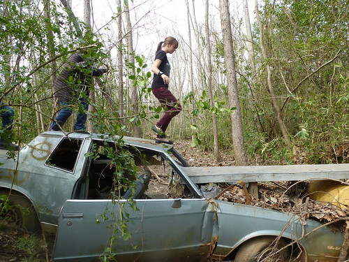
Maurice Loridans, member of A Better Shreveport and one of the informal custodians of the Coates Bluff Trail, says, "When you find a junked Monte Carlo half-buried in the slough, you've found a bridge that will take you to the newer section of Coates Bluff Trail." Loridans built the wooden tongue that extends from the windshield area of the wreck to the bank. He adds, "The new trail runs parallel to the original path but on the higher side of the bank along the old bayou."
The archaic bayou that forms the basis for the Coates Bluff Trail is Bayou Pierre. It was an active waterway when the course of the Red River was compromised by the log jam called the Great Raft by the Caddo Nation.
Feico Kempff, who is another maintainer and mapper of the trail, says "If you strike out north of the Monte Carlo bridge you will be on what I call the Red River Link. It's a an unimproved trail that can be enjoyed by the more adventurous types."
To reach the several woods trails of the Red River National Wildlife Refuge (150 Eagle Bend Point, Bossier City, 318-742-1219), take the Teague Parkway south of the Jimmie Davis Bridge. In about 1 mile you will see the entrance to the RRNWR on the right.
The RRNWR Center is a sustainable-model building filled with well-designed displays (love the giant garfish) that teach the flora and fauna of the region. Here you can pick up a map that will help you negotiate several paths.
No comments:
Post a Comment